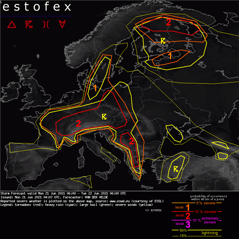
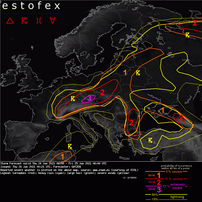
Ako ESTOFEX opet ne omane za Srbiju kao u prošli ponedeljak i danas.


Danas nisu Zapadnu Srbiju i Istočnu Bosnu stavili čak ni u tanku liniju, a tu je danas bilo ogromnog grada i kaže mi ćale da su u Ljuboviji i Bratuncu grad sakupljali lopatama. Danas oko Valjeva PGO rešetala ko da je u blizini ratište.


Ako i sutra omanu, počeću da verujem u teorije zavere geoinženjering koji možda vrši HARP ili ne znam ni ja ko.


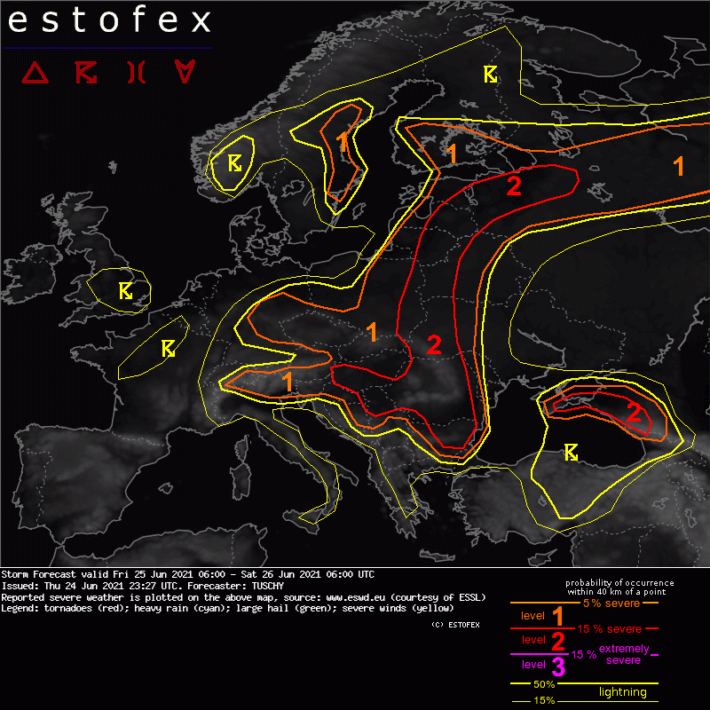
Storm Forecast
Valid: Fri 25 Jun 2021 06:00 to Sat 26 Jun 2021 06:00 UTC
Issued: Thu 24 Jun 2021 23:27
Forecaster: TUSCHY
A level 2 was issued across parts of E/SE Europe for large to very large hail, excessive rain and swaths of severe to damaging wind gusts.
A level 2 was issued for the E-Black Sea for similar hazards.
Both level 2 areas are surrounded by level 1 areas with similar hazards but with less coverage. In addition an isolated tornado threat is present.
A level 1 was issued for CNTRL Sweden mainly for heavy rain.
A level 1 was issued for S Finland mainly for an isolated tornado, hail and heavy rain event.
A level 1 was issued for parts of Germany mainly for heavy rain.
SYNOPSIS
A stable Rossby-wave pattern is in its progess to shift a bit east as another anomalous ridge approaches NW Europe and pushes the trough/ridge pattern over CNTRL Europe a bit E. This goes hand in hand with a subtle weakening trend of the positive geopotential height anomaly over far E Europe/Russia.
Anticyclonic wave breaking over NW Europe re-intensifies the longwave trough over W/CNTRL Europe with lowering heights over the UK shifting to the SW. Wave breaking results in a strengthening zonaly stretched ridge over N-Europe so not much change in the stagnant steering pattern is forecast. Nevertheless, the E-ward shifting wave pattern also pushes the most unstable air mass more towards E-CNTRL and E Europe.
A wavy synoptic-scale front runs from E Germany to the Baltic States into NW Russia and encompasses an extensive warm sector with a very unstable and partially capped warm/hot airmass. Prefrontal convergence zones/thermal troughs serve as an additional foci for CI during this forecast.
DISCUSSION
... Baltic States to the Black Sea ...
An extensive area experiences yet another day with rich BL moisture accumulation beneath modest mid-level lapse rates. Rich BL moisture was sampled by yesterday's sounding 26477 ULOL Velikie Luki with a well mixed and rather moist low-tropospheric layer up to 2.5 km AGL. LL mixing ratios approach 14 g/kg in the proximity to the frontal boundary. Therefore this CAPE plume features 800-1500 J/kg MLCAPE along its fringes with peak values next to the frontal boundary more in the 2000 to 3000 J/kg range, locally exceeding 4000 J/kg.
With a partially capped airmass, forcing/decaying outflow boundaries or diurnally strengthening LL convergence zones and the orography probably dictate CI. A progessive/sharpening short wave crosses Poland during the day, affecting the Baltic States during the overnight hours with a second/broader wave crossing N-Italy to the E and this wave should enter the far W Ukraine during the end of the night/forecast.
Therefore at least two convective episodes exist, which overlap partially in time and region.
NW-Ukraine to the Baltic States into NW Russia ... a gradually decaying MCS crosses the Baltic States from SW to the NE until noon (although substantial uncertainties exists as this cluster is already well ahead of most NWP guidance). The NWP guidance supports a temporal weakening trend but with another rapid uptick around noon. So would not be surprised to see this cluster re-intensifying over the E-Baltic States when moving E/NE towards NW Russia.
Further upstream the next short wave interacts with the CAPE plume and supports the next round of clustering thunderstorms with numerous extensive clusters forecast (shifting E and NE, depending where they evolve).
DLS will stay around 10 m/s with similar values in the lowest 3 km AGL, so the main driver for swaths of regionally enhanced severe wind gusts will be cold pool dynamic. Besides that, forecast soundings reveal distinct signatures for damaging wet downburst events. Fat CAPE profiles but rather weak SR winds should support a mixture of large hail or copious amounts of smaller hail. A giant hail event can occur in case of orographic modifications of the local wind field. Excessive rain will be another hazard and even a local tornado event is possible but this risk depends on mesoscale events/nowcast.
Expected high coverage of severe events prompted us to upgrade to a level 2 despite weak to modest kinematics.
W/SW Ukraine to Romania/Bulgaria ... This area resides beneath the weakest dynamics during the daytime hours. CI also depends on the orography or diurnal driven convergence zones. Scattered mountain convection, growing into a few small clusters is certainly possible. Severe events are likely with this activity, including large hail, severe downbursts and heavy rain.
During the late afternoon/evening into the night, an overall uptick in activity is forecast with numerous large and cold pool driven thunderstorm clusters forecast (maturing clusters from the day and due to the approaching short-wave). Again, to forecast any hot spot is hard to impossible right now with a lot depending on the development in the nowcast. Swaths of severe to damaging wind gusts are forecast as well as large to isolated very large hail. During CI, storms remain quasi-stationary for some time with very weak low-tropospheric flow and this activity could produce numerous flash flood events before progressing with deepening cold pools. Overall this area also deserves an upgrade to a level 2 because of the expected high amount of severe weather events. Not much weakening of this activity is forecast with rich CAPE being available all night long.
... S/CNTRL Germany into the Czech Republic and SW Poland ...
Lingering moisture beneath the upper trough offers moderate CAPE with 400-800 J/kg MLCAPE. DLS decreases from 10-15 m/s over SW Poland to 1 m/s over CNTRL Germany. Weakening convection from the previous night probably re-intensifies during the day with better shear over the Czech Republic into SW Poland offering another round of lined-up convection with strong to isolated severe wind gusts and hail. Towards Germany the main risk will be excessive rain with slow moving convection. A broad level 1 should cover that risk although regionally level 2 equivalent flash flood reports are well possible. Worked-over air mass with moderate CAPE kept this event in a level 1.
... Extreme SE Austria into E Slovenia and Hungary and E Croatia into Serbia ...
Another (but borderline) level 2 was issued for a potential MCS event during the afternoon into the night. Early and widespread CI is forecast along the Alpine rim (level 1 for heavy rain and hail). Maturing thunderstorms then enter the southern foothills with MLCAPE between 1-2 kJ/kg and rapidly improving wind profiles (DLS well in excess of 20 m/s and 0-3km shear exceeding 15 m/s). With a dry/well mixed BL airmass, strong downdrafts and consolidating cold pools favor a progressive MCS towards Hungary with severe to damaging winds and hail. This is a borderline level 1/2 situation but the wind risk pushed this over the level 1 threshold.
The level 2 was expanded S towards Serbia, where mountain convection also poses a similar risk during the afternoon/evening. CAPE/shear space favors progressive MCS events with severe to damaging winds and large hail (next to heavy rain). CI is unclear, hence this level 2 was merged with the broad level 2 further E.
... E Black Sea ...
Yet another level 2 was issued for slow moving multicells with large hail, excessive rain and numerous severe downburst events. Betimes this activity grows upscale into slow moving clusters before weakenig until 06Z.
... CNTRL Sweden and S Finland ...
A level 1 was issued for S Sweden mainly for heavy rain with slow moving thunderstorms during the afternoon into the evening hours. 400-800 J/kg MUCAPE with barely any flow favors pulsating and slow moving convection.
DLS increases to more than 15 m/s over S Finland with somewhat enlarged 0-3 km hodograph. A few shallow mesocyclones including an isolated tornado event can't be ruled out with low LCLs and enhanced LL directional shear. Heavy rain and isolated hail will be the dominant hazard however.


