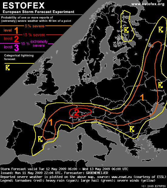
ESTOFEX:

Storm Forecast
Valid: Tue 12 May 2009 06:00 to Wed 13 May 2009 06:00 UTC
Issued: Mon 11 May 2009 22:04
Forecaster: GROENEMEIJER
A level 1 was issued for parts of France and NE Spain mainly for large hail.
A level 2 was issued for E France, S Germany, N Switzerland, and NW Austria mainly for large hail, and severe winds.
A level 1 was issued for an area surrounding the level 2, across Germany and the Alps mainly for large hail, and severe winds.
A level 1 was issued for the Dinaric Alps, the Pannonian Plain, Romania mainly for large hail.
A level 1 was issued for the W and central Ukraine, SE Belarus and W Russia for large hail and severe winds.
SYNOPSIS
Tuesday at 0600 UTC, mid-level charts feature an intense trough from northern Scandinavia to W Poland. During the forecast period, a low cuts off from the trough and becomes established over Smolensk Oblast. There, intense surface cyclogenesis is also expected as the upper-level systems interacts with a frontal zone. Upstream of the trough, a ridge stretches from the Shetlands to W Germany. Further upstream, a low is situated over the Bay of Biscay. On the SE flank of that low, a 30 m/s jet streak is present from SW Iberia to the Alps. While being well-defined in the lower troposphere also, it tends to propagate downstream somewhat during the period. A subtle shortwave ridge over Iberia moves NE ward and connects with the Shetland-W Germany ridge. A baroclinic zone stretches across eastern Spain towards central France. A clear surface front stretches eastward across Europe, from the Paris region eastward across southern Germany to N Hungary, to E Belarus -- where the surface cyclogenesis is expected -- and onwards along the Valdai Hills to the northern Russian Plain.
DISCUSSION
E France, S Germany, Switzerland, Austria, N Italy...
A rather moist air-mass that has become stagnant south of the warm front mentioned above. As this air-mass is warmed during the day, CAPEs well in excess of 1000 J/kg, possibly up to 2000 J/kg are expected to form north of the Alps. This, in combination with strong 20-25 m/s shear, will lead to a situation in which rotating storms can develop with ease. Scattered storms will probably form in the early afternoon in response to diurnal heating. They will bear a threat of large hail. A risk of severe winds will also exist. The risk of tornadoes appears not to be exceptionally large, because of the relatively low 0-1 km shear. However, high amounts of low-level buoyancy and locally enhanced shear may still allow for one or two tornadoes to develop, especially in vicinity of the front.
The storms may continue into the evening, but will gradually subside.
Across the Alps and on the southern flanks of the Alps, storms are also expected to occur. Instability will be less, so the threat of large hail will be a bit lower, but still significant. Some severe wind gusts are possible in addition to the hail threat.
N Dinaric Alps, Pannonian Plain, Romania...
Scattered storms are expected to form in this region also, under somwhat weaker shear. Hence, rotating updraughts will be rarer. Still a few events of large hail are possible.
Central France...
Weak capping just south of the aformentioned warm front will likely lead to widespread initiation of storms across central France. Shear will probably be rather weak across central and western parts of France, but will be higher in the east and south, and across northeastern Spain. CAPE on the order of 1000 J/kg is expected, which suggest that a couple of storms that manage to become well-organized multicells could produce some severe hail.
S France, NE Spain...
As a subtle shortwave ridge approaches during the day, convective initiation is inhibited across southern France and NE Spain, until in the evening. Then, convective initiation is still possible, and some storms will porbably form. The environment may be able to sustain a few supercells as 0-6 km bulk shear should be around 20 m/s. A few large hail events will be possible.
Ukraine, Central Russian Upland, Smolensk-Moscow Upland...
In response to the approaching trough, upward vertical motion is expected to occur increasingly within the warm air-mass east of the front, and convective storms are expected to form in the morning. Moderate deep-layer shear, around 15 m/s, and CAPE around 1000 J/kg indicate that soem threat of large hail will exist.
Additionally, as low-level winds increase in response to pressure falls, the storms may produce a few severe wind gusts, It is expected however, that the convection will cease during the evening as instability diminishes.
Pračenje sa foruma:
20:46 h - oblak se formirao na Zg područjem te je nastavio put prema Slavoniji:
Par fotki oko 19:45 sati, kad je Chinookov cb na sjeveroistoku bio najbliže meni i kad je najviše grmilo i sjevalo:
Uhvatih dvije munje, a nekoliko lijepih primjeraka mi je nažalost pobjeglo.


21:41 h
Močno izgleda, kako mi se približava tako jača, trenutno naraslo na 62 dbZa

22:16 h
Uhuhuh, superćelija sa maksimalnim odrazom nad Velikom....mislim da nema sumnje - to je led i to jak.

22:19 h
Vrtlo toplo i sparno, vjetar 0 m/s
Nevjerovatno koliko sijeva, ovaj glavni izgleda ide na mene

aaaaaaaedwfgezh rze najjjači odraz ( sory na uzbuđenju)

22:40 h
na ulazu u slavonski brod :shock:

22:58 h
Slav. Brod led veličine lješnjaka sa kišom padao oko 4-5 minuta. Ostalo ga je na mjestima i po 5-6 cm.


