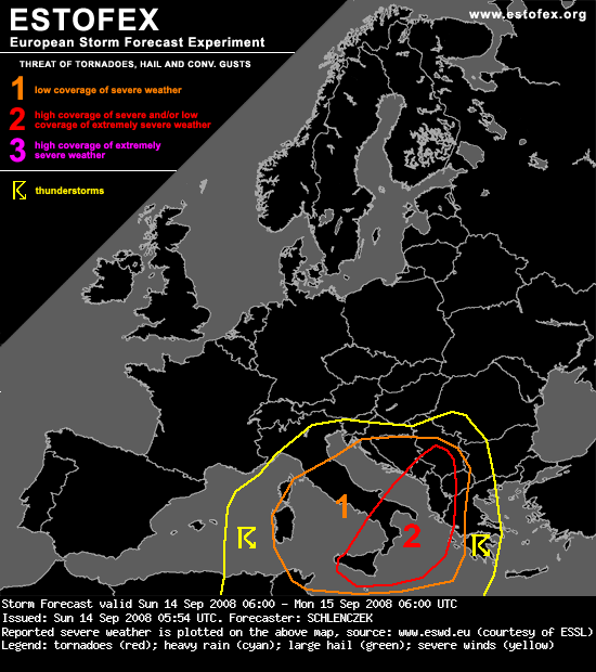
Estofex za danas

SYNOPSIS
An upper level cut off low over the central Mediterranean Sea is forecast to travel eastward while weakening. Ahead of the low, a strong 40 m/s jet streak at 300 hPa stretches from the Balearic Islands via southern Sardinia and central Italy towards Slovenia. Its left exit region should move from Croatia towards Albania and northern Greece during the forecast period. The surface cold front will move from southern Italy towards Greece. Ahead of the cold front, very moist and unstable air is advected into the eastern Mediterranean region and Greece. High pressure over Scandinavia leads to stable conditions in most parts of northern / western Europe.
DISCUSSION
...Central / eastern Mediterranean...
Very unstable air and moderate deep layer shear will persist in the central Mediterranean region with organized severe thunderstorms being likely.
Over the southeastern part of the region, GFS suggests MLCAPE in order of 3 kJ/kg with T / Td around 30 / 20 °C ahead of the cold front but soundings will probably show smaller values as the low-level moisture depth is variable across the whole region. Especially over the Ionian Sea, where instability should be best, at least 15 m/s deep layer shear will be in place. Locally, SRH3 in order of 200 - 400 J/kg and SRH1 around 200 J/kg is forecast for western Greece on Sunday afternoon. Latest GFS outputs show a small 25 m/s speed max at 700 hPa but the exact time and location of such a feature is rather uncertain. Some DCVA should overspread the Ionian Sea and Albania / Greece during the first half of the forecast period with strongest forcing expected over extreme N Albania.
Some intense storms have developed in the last few hours and storm coverage should increase during the morning / afternoon. There should be at least a few well-organized multicells and supercells with a threat of large / very large hail and damaging gusts. Later on, storms could merge into one or two large MCSes that will likely be accompanied by widespread severe gusts and torrential rain with local flash floods not ruled out. Low LCL heights, steep lapse rates ahead of the front and locally enhanced SRH / LL shear suggest that an isolated, possibly strong, tornado is not ruled out. Storms will likely continue during the night and should reach southern Romania / western Bulgaria on early Monday morning.


