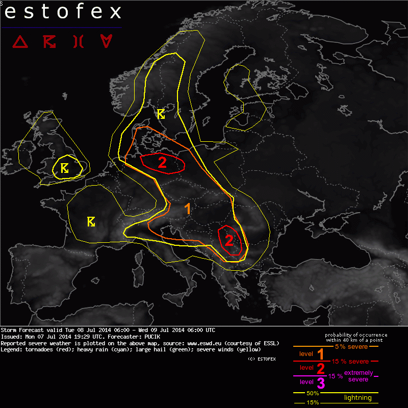
Estofex za sutra..

Ja samo da dodam tekst :
Storm Forecast
Valid: Tue 08 Jul 2014 06:00 to Wed 09 Jul 2014 06:00 UTC
Issued: Mon 07 Jul 2014 19:29
Forecaster: PUCIK
A level 2 was issued for NE Germany mainly for excessive precipitation and to the lesser extent for tornadoes, marginally large hail and severe wind gusts.
A level 2 was issued for parts of Serbia mainly for (very) large hail, severe wind gusts and to the lesser extent for excessive precipitation.
A level 1 was issued for Denmark E Germany, SW Poland, Czech Republic, Slovakia, Hungary, Austria, NE Italy, Slovenia, Croatia mainly for excessive precipitation and to the lesser extent for marginally large hail and severe wind gusts.
SYNOPSIS
A long-wave trough over the Atlantic will experience a transition into a cut-off low centered over France by Tuesday evening. Strong mid-level flow is simulated especially over the southern flank of the low / trough, with windspeeds over 25 m/s at 500 hPa level. Closer to the surface, a cyclogenesis is simulated along the wavy frontal zone running from NW Germany towards W Czech Republic, Austria and Italy. Ahead of the front, a warm and moist airmass is observed with marginal to moderate degree of latent instability per 12 UTC Monday soundings. Models simulate numerous surface convergence zones associated with this frontal boundary, which will likely result in a scattered to widespread tstm initiation in a belt from Germany towards Serbia. This belt requires the most attention during the forecast period.
DISCUSSION
... Northeastern Germany ...
Models are in general agreement regarding the deepening of the surface low over NE Germany. To the north of the low, easterly to southeasterly flow will advect warm and moist airmass from Poland. Around 1000 J/kg of MLCAPE is forecast with mixing ratios generally between 11 and 15 g/kg especially in the zone of the surface convergence. Weak to moderate degree of vertical wind shear is forecast, with DLS values mostly between 10 to 15 m/s. However, towards the late afternoon and evening, with enhancement in the low-level flow, a belt of LLS over 10 m/s and SREH over 150 m2/s2 should form to the north of the convergence zone.
Current thinking is that numerous storms will initiate along the convergence zone, likely attaining form of the multicell clusters. With moist airmass, low LCLs rather slow storm motion and parallel flow to the convergence zone, the most prominent threat should be excessive rainfall. Perhaps the greatest degree of storm clustering will be observed in the evening to overnight hours. Stronger cells may be capable of marginally large hail and wind gusts. Moreover, in case that an isolated supercell manages to develop in this setup, tornadoes may become a threat thanks to the enhanced LLS and low LCLs.
... SW Poland, Czech Republic, Slovakia, Austria, Slovenia, NE Italy ...
Similar setup with less favourable conditions than in case of NE Germany, especially regarding weaker low-level flow and less wind shear is forecast for this region. Still, moist airmass along with weak storm motion will contribute to the enhanced threat of excessive precipitation event especially along the local convergence zones. Stronger cells developing in moderate MLCAPE around 1000 J/kg may produce marginally large hail (or high amounts of small hail) and/or marginally severe wind gusts.
... Serbia and surrounding area ...
A plume of steep mid-level lapse rates is forecast to be advected over the region, originating from N Africa. Degree of CAPE values is somewhat uncertain attm, but it seems that the best low level moisture should exist over Serbia, S Hungary and W Romania, where CAPE values around 1000 J/kg may be realised. Models generally diverge on the arrival of the enhanced mid-level flow towards the afternoon and evening and thus also on the degree of the vertical wind shear. Still, it seems that especially region should see 15 - 20 m/s of DLS, increasing southwards and also towards the evening.
Storm initiation is uncertain attm, but if storms manage to form (especially towards the evening as short-wave trough arrives), area may see a distinct threat of supercellular convection capable of (very) large hail and severe wind gusts. Storm clustering towards the evening may enhance the excessive precipitation threat as well. A low end Lvl 2 is issued for a small area where the best CAPE / shear overlap is forecast.
Moj kraj je u lvl 2 .


