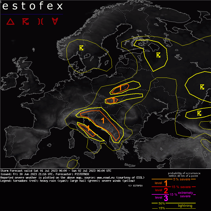
Srbija, Bosna i Hercegovina, Crna Gora i Hrvatska sutra će biti u kecu.
Storm Forecast
Valid: Sat 01 Jul 2023 06:00 to Sun 02 Jul 2023 06:00 UTC
Issued: Fri 30 Jun 2023 21:16
Forecaster: PISTOTNIK
A level 1 is issued for Bosnia-Herzegovina, Montenegro, Albania and parts of Serbia and North Macedonia mainly for excessive convective precipitation and to a lesser degree for large hail.
A level 1 is issued for parts of Italy, Croatia, Slovenia, Slovakia and central Poland mainly for excessive convective precipitation.
SYNOPSIS
A high-index pattern has established with a straight jetstream in the mid-troposphere whose axis runs between 50N and 55N from the British Isles to Belarus. Two surface cyclones travel slowly eastward across the Baltic Sea and the North Sea, their frontal systems crossing east-central Europe and west-central Europe, respectively.
Further south, a weak cut-off low shifts from central Italy (Sat 06 UTC) to Serbia (Sun 06 UTC). In its wake, cooler air also spills into the central Mediterranean region.
Anticyclonic conditions with warm to hot air are confined to SW and SE Europe.
DISCUSSION
... W Balkans ...
Despite modest lapse rates, rich low-level moisture allows the buildup of CAPE on the order of 500-1200 J/kg after some hours of insolation. Synoptic lift ahead of the cut-off low, a generally converging near-surface wind field and upvalley/upslope circulations in mountainous terrain will allow scattered to widespread thunderstorms, mostly in the afternoon and evening. With a slow storm motion and a high storm coverage, excessive rain is the main hazard and may result in some flash flood events. The hazard appears highest in and around Bosnia-Herzegovina, but low model agreement on the amount of sunshine, and hence the magnitude of CAPE, preclude a level 2 for now.
Towards the south, limited synoptic lift support will keep storm coverage lower, but somewhat steeper lapse rates and slightly stronger deep-layer shear (10-15 m/s) can enable multicell storms with additional hazards of large hail and localized downbursts next to heavy rain.
... from Italy across east-central Europe into S Finland and NW Russia...
Due to its maritime origin, the cool to moderately warm air in the band of westerly winds features seasonable low-level moisture but poor lapse rates, which confines CAPE to values around or below 500 J/kg. Scattered, partly thundery shower activity is expected across wide areas, mostly following a diurnal cycle, but their severe weather hazard is low. A few heavy rain events are possible, mainly in parts of Italy, Slovenia and Croatia, as well as in a zone of enhanced moisture at the cold front across central Poland and Slovakia. Otherwise, they will likely be too widely scattered to issue larger level 1 areas.
Near the center of the cut-off low, morning convection (not necessarily electrified) can also affect the N Adriatic and to a lesser degree the Ligurian Sea, where one or two non-mesocyclonic tornadoes are possible.


