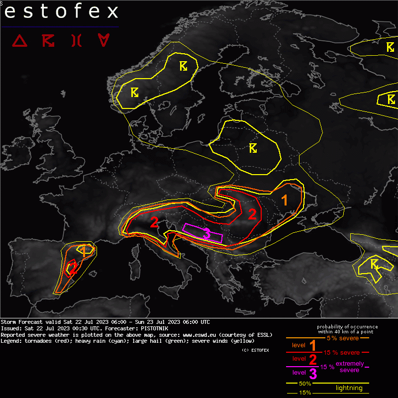
A level 3 is issued for parts of Bosnia-Herzegovina and Serbia for large hail and severe convective wind gusts.
A level 1 and level 2 are issued for E Spain mainly for large hail.
A level 1 and level 2 are issued for NW to E Italy mainly for large hail and to a lesser degree for severe convective wind gusts and excessive convective precipitation.
A level 1 and level 2 are issued for NE Italy, S Austria, Slovenia, Croatia and SW Hungary for large hail, severe convective wind gusts and excessive convective precipitation.
A level 1 and level 2 are issued for Serbia, Romania, E Slovakia and the W Ukraine for large hail, severe convective wind gusts and to a lesser degree for excessive convective precipitation.
A level 1 is issued for Moldova and the central Ukraine for excessive convective precipitation, large hail, severe convective wind gusts and to a lesser degree for tornadoes.
DISCUSSION
... belt from E Spain to Romania ...
On the warm side of the frontal boundary, a pronounced elevated mixed layer (EML) is continuously replenished by strong heating of dry and elevated terrain over NW Africa and Spain. The strong WSW-erly mid-level flow picks it up and advects it across much of the Mediterranean Basin, Italy and the Balkans. Moderate to high CAPE builds in those zones where plentiful low-level moisture accumulates beneath the EML: (1) in the range of the mentioned frontal boundary, (2) on the NE side of mountain chains, where moist upvalley and upslope flows are trapped beneath the capping inversion, and (3) in general over the sea surfaces (where capping is too strong to allow convective initiation, though). The expected CAPE magnitude on Saturday is again 1000-2000 J/kg across wide areas, with maxima regionally up to 3000 J/kg where a particularly deep moisture pool can be achieved (e.g., see Fri 12 UTC Belgrade and Nis soundings).
Thanks to the strong mid-level jet, 0-6 km shear around or above 20 m/s overspreads almost the entire CAPE reservoir, and even up to 30 m/s its southern portions. The overlap of CAPE and vertical wind shear is therefore once more outstanding for organized and severe convection!
The area of highest concern is the downwind side of the Dinaric Mountains in Bosnia-Herzegovina and Serbia. On Friday, a supercell produced up to 11 cm sized hailstones in N Bosnia-Herzegovina in a pretty similar situation. The belt of maximized moisture along the frontal boundary is expected to push ~100 km south into the mountains and shift 200-300 km eastward into the bordering regions of Bosnia-Herzegovina and Serbia on Saturday. Comparing the atmospheric conditions expected on Saturday to those observed on Friday, 2m dewpoint and therefore CAPE will likely decrease a bit, whereas both deep-layer shear and 0-3 km storm-relative helicity (SRH3) will even further increase.
Synoptic lift of a short-wave trough grazes the area in the course of the afternoon. In addition, outflow boundaries and/or frontal cross-circulations may push southward then. Convective initiation therefore appears likely enough to expect a few supercells. In an environment of 1500-2500 J/kg CAPE, 25-30 m/s deep-layer shear and >200 m^2/s^2 SRH3, another instance of 8-12 cm sized hail is not ruled out!
The northern fringes of the discussed area will be more strongly influenced by the mentioned short-wave trough in the afternoon, hence the highest storm coverage is expected over NE Italy, Slovenia, and parts of Austria, Hungary and Croatia then. Under strong synoptic lift but comparably modest CAPE around or below 1000 J/kg, storms will initially tend to form clusters rather than organize very well, which limits their severity to some degree. Nonetheless, a high enough density of severe weather events for a level 2 is anticipated already in their early stages in the southern Alps. The hazards appear to be fairly evenly distributed between excessive rain, large hail and severe wind gusts.
Towards evening, convection will increasingly propagate towards the abundant CAPE reservoir over Croatia, Bosnia-Herzegovina, Serbia or even Romania, and both a few supercells with very large hail and/or later another bow echo with widespread severe to extreme wind gusts become a distinct probability, adding to the level 3 threat discussed above.
Convection will only slowly weaken and decouple from the surface overnight while it continues to move across Romania and perhaps even into parts of Bulgaria.


