Storm Forecast
Valid: Sat 05 Aug 2023 06:00 to Sun 06 Aug 2023 06:00 UTC
Issued: Fri 04 Aug 2023 22:38
Forecaster: PUCIK/KUZMENKO
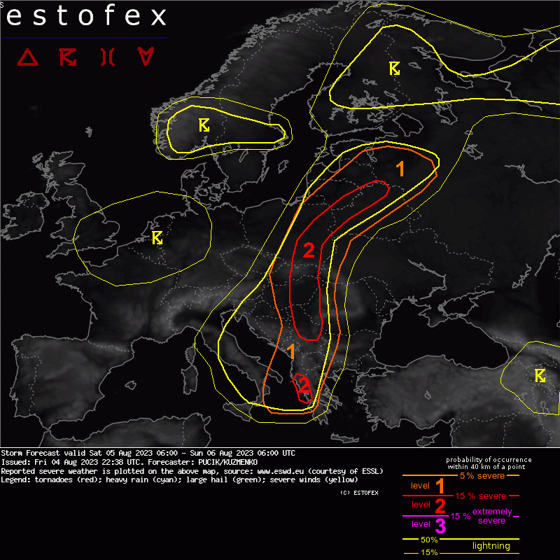
A level 2 was issued across Serbia and Hungary for damaging wind gusts, heavy rainfall and large hail.
A level 2 was issued across Slovakia and S/SE Poland mainly for heavy rainfall, severe wind gusts and to the lesser degree for tornadoes and large hail.
A level 2 was issued across NE Poland, SE Lithuania and NW Belarus mainly for severe wind gusts, tornadoes and heavy rainfall.
A level 2 was issued across NW Greece mainly for heavy rainfall and severe wind gusts.
A level 1 was issued across W Slovakia, central Poland, Lithuania, Latvia and SE Estonia mainly for heavy rainfall and to the lesser degree for severe wind gusts.
A level 1 was issued across S Bosnia, North Macedonia, Albania, W Romania and W Bulgaria mainly for large hail, severe wind gusts and heavy rainfall.
SYNOPSIS
A trough over Italy will detach from lower geopotentials over NW Europe by Saturday 06 UTC. The resultant low will move E/SE towards the Ionian Sea. Further W, a short-wave will move across BENELUX and N France in the late afternoon to evening hours. Abundant low-level moisture will be confined to the wavy frontal boundary that will run from NW Greece, W Serbia into Hungary, Slovakia, Poland, N Belarus and E/SE Baltic countries. Severe thunderstorms are forecast in this belt.
DISCUSSION
... Serbia, W Romania, Hungary, Slovakia, SE Poland ...
Numerous storms are forecast to be ongoing across Slovakia/S Poland in the morning hours. These storms will move N and clouds will break especially over the E part of the area. Surface heating will increase MLCAPE values, which may locally reach 2000 J/kg. Strong deep layer shear will support well-organised storms. Hodographs will be mostly straight with increasing 0-3 km shear towards the evening hours. Stronger low-level shear, along with curved hodographs, is forecast over central-E Poland, where tornado risk will also be present in the afternoon hours. First, isolated storms will form and organize rapidly into supercells with threats of large hail and/or severe wind gusts. Towards the late afternoon and evening, one or more systems will form over Serbia and S Hungary in response to frontogenesis and move towards N/NW. There will be high risk of severe wind gusts at first, especially over the S and E half of the Lvl 2, giving way to higher risk of heavier rainfall in the late night hours as storms become elevated.


