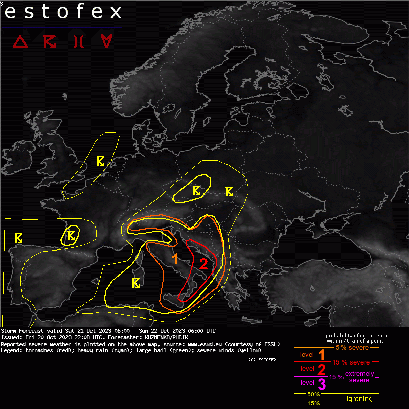
Estofex nas stavio u level 1. Pre svega mislim na moj kraj Zapadnu Srbiju i Istočnu Bosnu. Ovih 25C u 4 sata noću mnogo podseća na noć 3./4. oktobra 2020.


Storm Forecast
Valid: Sat 21 Oct 2023 06:00 to Sun 22 Oct 2023 06:00 UTC
Issued: Fri 20 Oct 2023 22:08
Forecaster: KUZMENKO/PUCIK
A level 2 was issued for S/SE Italy, S Croatia, W Montenegro, NW Albania for heavy rainfall, large to very large hail, tornadoes and severe wind gusts.
A level 1 was issued for Sicily mainly for large to very large hail, severe wind gusts, tornadoes and heavy rainfall.
A level 1 was issued for W Italy mainly for heavy rainfall and marginally large hail.
A level 1 was issued for N Italy, W Slovenia and NW Croatia mainly for large hail and heavy rainfall.
A level 1 was issued across Bosnia, NE Croatia and S Hungary mainly for heavy rainfall and marginally severe wind gusts.
DISCUSSION
... Lvl 2 area, Sicily towards S Croatia, Montenegro and Albania ...
A cold front and a pronounced negatively-tilted short-wave trough at the upper troposphere is forecast to cross the area. Scaterred to widespread storms are forecast in the N edge of the Lvl 2 already in the morning hours. Storms are expected to spread E and S during the day and evening. Compared to the previous days, storms in this area will form in the environment of high CAPE, thanks to the steep mid-tropospheric lapse rates that have been advected from N Africa. Forecast hodographs show vertical wind shear supportive of well-organised storms, both supercells and quasi-linear convective systems, including bow-echoes.
All hazards will be possible across the area. Very large hail will be most likely over Italy, where the highest likelihood of isolated supercells will be and where the highest CAPE values below -10 deg C are forecast. The highest risk of heavy rainfall is forecast across the E Adriatic coastline as the low-level jet develops over the sea and continuous initiation of new cells is expected. Tornadoes and severe wind gusts will be possible as well, given strong low-level shear, including high values of SRH in the bottom 500 m. Severe wind gust risk may be mitigated to some degree by the low LCLs in the maritime airmass. The exact nature of hazards will likely be determined by the exact convective mode across different areas.
... W Italy coastline ...
Convective coverage will decrease during the late afternoon to evening as dry air at the mid-troposphere is advected over the area. Before this happens, scatterred to widespread storms are forecast over the area with the highest degree of organisation across the S part of the area. Shear will decrease during the day. Dominant threat will be heavy rainfall, but marginally large hail may occur as well. Dominance of CAPE in the lower part of the cloud will reduce the large hail risk to some degree.
... N Italy, NE Adriatic ...
Scatterred storms are forecast to develop in the afternoon hours. With 0-6 km bulk shear between 15 to 20 m/s, a mix of multicells and supercells is likely. Given high values of CAPE in the cold part of the cloud, large hail may occur with stronger updrafts. Heavy rainfall will be second the hail threat. While severe wind gusts are not completely ruled out, low LCLs will limit the intensity of individual downdrafts.
... Bosnia, NE Croatia, W Serbia, S Hungary ...
A marginal Lvl 1 is issued for embedded storms that develop within a stratiform rainband that moves between the area after 12 UTC. Strong vertical wind shear is forecast, including in the lower troposphere, but CAPE profiles are either skinny on the models or elevated. Nevertheless, decided to introduce a Lvl for a highly conditional threat of isolated heavy rainfall and/or marginally severe wind gusts.


