UPOZORENJE ZA SLOVENIJUPopoldne in zvečer močne nevihteLokalna neurjaDanes popoldne in zvečer so možne močnejše nevihte s točo, močnimi nalivi in močnim vetrom.3. STUPANJ OPASNOSTI! 


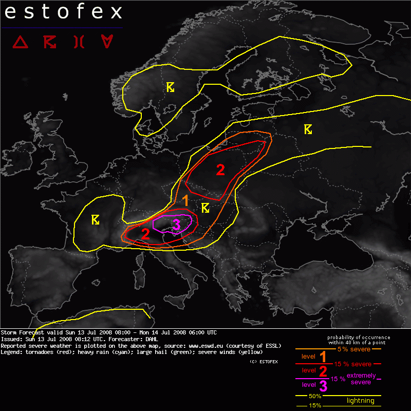
Storm Forecast
Valid: Sun 13 Jul 2008 08:00 to Mon 14 Jul 2008 06:00 UTC
Issued: Sun 13 Jul 2008 08:12
Forecaster: DAHL
SYNOPSIS
*** Active severe weather day expected over the N Mediterranean and portions of east-central Europe ***
Deep and quite intense, quasi-stationary upper long-wave trough is covering the western parts of Europe, slowly beginning to evolve into an upper cut-off cyclone over the Alpine regions late in the period. Several smaller-scale vorticity maxima are imbedded in the strong SSWLY upper flow at the eastern side of the large-scale trough. A well-defined low-level baroclinic zone is stretching from SW Iberia diagonally across Europe via the Baltics into NW Russia at the beginning of the forecast period ... and will become more north-south oriented by the end of the period. At the surface, two high pressure areas over the E Atlantic/W Europe and over E Europe/W Russia are surrounding a weak low-pressure region aligned with the main low-level front. The air mass immediately to the E of this frontal zone is exhibiting rather strong low-level moisture variations, so that profiles range from Miller-type I soundings (E Spain) to inverted-V (N Balkans). GFS predicts mean 0-1 km mixing ratios in excess of 10 g/kg on the immediate warm side of the front in the afternoon and evening hours.
DISCUSSION
... N Italy ... extreme S Austria ... extreme NW Balkans ...
00Z ascents from N Italy and the N Balkans suggest that depth of low-level moisture is rather low, though continued evapotranspiration along with mesoscale convergence may at least locally lead to appreciable depths of boundary-layer moisture. Still, some variability in LCL height as well as CAPE strength might exist today. Where moisture has accumulated, CAPE may increase to 2000 J/kg.
Impressive deep-layer shear is present over the region, exceeding 25 m/s throughout the period. LLS is initially expected to be rather weak, but to increase over NE Italy and the extreme NW Balkans in the late evening hours, exceeding 10 m/s per GFS.
An upper vort max is currently crossing the region, but WV imagery suggests that a dry slot is overspreadign the unstable air over N Italy, increasing confidence that unimpeded insolation will be realized over N Italy during the next few hours. QG-forcing for ascent should increase again in the late afternoon and evening hours upon approach of the next vort max.
Convective initiation may be delayed somewhat in the wake of the first vort max, aiding in the buil-up of instability and suppressing widespread storm development. Isolated storms should initiate in the afternoon hours, however, given sustained low-level warm advection and suspected mesoscale regions of LL convergence associated with orography or mesoscale boundaries laid out by earlier convection. Coverage should increase later in the day as large-scale forcing for ascent overspreads the area.
The cells that form should immediately become supercellular, main threat being large hail and damaging winds. It seems that the hail threat will be maximized where low-level moisture will be deepest, and very large hail, well in excess of 5 cm in diameter, may occur. As coverage increases, storms may merge into linear segments/bow echoes.
In the evening hours, it seems that rich low-level moisture/strong CAPE and quite favorable shear profiles will coincide, which suggestss that an additional threat for tornadoes will exist. Anticipated storm coverage and degree of severity necessitate a level-three threat.
... N Czech Republic ... NW Slovakia ... Poland ...
Steep mid-level lapse rates and rich low-level moisture should persist over Poland, and thunderstorms should develop in association with a frontal wave, propagating northeastwards along the front during the period.
CAPE should rise to about 1500 J/kg during the afternoon hours, while DLS should be in the 15 to 20 m/s range. Most striking is the simulated LLS which increases to 15 m/s in the afternoon and evening hours. Any storm developing in this environment will likely become supercellular ... with a distinct threat for tornadoes - apart from large hail and damaging straight-line wind gusts.
VIR: ARSO, www.estofex.org


