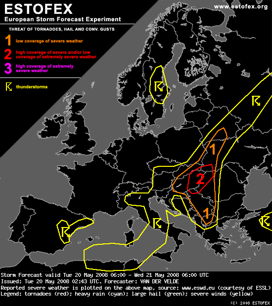
Današnji Estofex

SYNOPSIS
Three low MSL-pressure areas are present on the map today, the main one centered over Italy, a weak one over Scandinavia, and an Atlantic low far away from the continent. A weak ridge stretches from Iceland via the UK towards Portugal.
Most interesting is the Mediterranean low with its extension over the Balkan filled with an unstably stratified airmass with predicted MLCAPE values in the 500-1500 J/kg range. Southeast of an elongated stationary occlusion over Russia/southeast Belarus towards Slovakia and Slovenia thunderstorms will concentrate near zones of enhanced low level convergence. Over this zone, a southwesterly mid level flow creates locally moderate deep layer shear, especially over the Balkan where warm air advection creates veering winds with height favorable for supercell and long-lived multicell clusters.
West of the surface warm front, over eastern Austria and southern Czech Rep. elevated CAPE is present and some thundery convection may be embedded in stratiform rain.
DISCUSSION
...central and northwestern Balkan...
GFS theta-e fields at 700 hPa shows an advance of lower values northward over the Adriatic Sea into western Hungary. At lower levels this is less pronounced, but it seems this feature is a weak cold front. A weak jetstream follows the same curved path. However, this means the area of instability resides mostly at the right exit side of the jet and may experience some subsidence at higher altitudes.
GFS has consistently produced moderate MLCAPE and moderate deep layer shear (about 14-18 m/s 0-6 km) coming together in the region around Hungary. The surface front is sharply defined, where LCL heights are low. 0-1 km shear seems to be predicted to be favorable to tornadogenesis (>10 m/s) - however - probably on the cold side of the front with no instability.
SREH-3 km is enhanced through an area more overlapping with instability, according to the model in the eastern half of Hungary - NW Romania corner. This depends mostly on 10m winds from northerly or easterly directions. Storms developing in this area have increased probability of becoming supercells with large hail, gusts and flash floods.
But also persistent multicell clusters, possible in a larger region, bear a good chance of large hail. Would not be surprised to see an isolated report of hail beyond 4 cm.


